By Esther Fung
It is one of the biggest headaches for delivery services and gig couriers. They have the address where a person lives. But how do they find the right apartment—or even the right building—quickly?
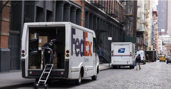
Garden-style complexes, mobile-home parks and university campuses can have labyrinthine layouts where numbers may not be in sequence, making deliveries a time-consuming nightmare, drivers say. Just finding the right door in multiunit buildings can take as much as 30 minutes, compared with 30 seconds when making a delivery to a free-standing, single-family home.
To ease things for delivery people, companies like Amazon.com, FedEx and United Parcel Service use map software that locates things like mailrooms and out-of-the way entrances. Gig workers mostly don’t have that kind of specialized information, and usually have to lean on GPS services like Google Maps that can only guide them to the front door. Some, though, are turning to startups that offer specialized maps created from building blueprints and other data.
Avoiding mix-ups can reduce costs for the shipper, cut headaches for the recipient and improve reliability ratings for the delivery company. In some urban areas, the majority of drivers’ time is spent outside of vehicles, including searching for the right apartment, says Anne Goodchild, founding director of the Urban Freight Lab, which does research on urban freight and logistics issues at the University of Washington.
“These are kind of pedestrian, unsexy parts of the problem,” Goodchild says.
Where’s the customer?
While carriers have spent years investing in tools to help drivers take the most-efficient and least-costly routes to drop off packages, improving the so-called last inch of the process—getting to customers’ doorsteps—has proved to be a lot tougher.
Larger parcel carriers have adapted the route-optimization software—designed to find the most-efficient directions while taking into account traffic congestion and weather—to help delivery workers navigate buildings.
“When available, our app provides drivers with helpful information that informs them of what side of the street a delivery is on, the layouts and mapping of multiunit complexes, and shared delivery points at locations like college campuses,” says Branden Baribeau, an Amazon spokesman. He adds that drivers also get photographs on Amazon’s delivery app of buildings, units and mailrooms to help them confirm the correct location.
FedEx, meanwhile, says it has Global Positioning System software that alerts couriers if they arrive at a spot that is too far away from the delivery address. And UPS’s navigation platform, On-Road Integrated Optimization and Navigation, or Orion, provides UPS drivers with details such as package drop-offs and loading docks not visible from the street.
All of these details are critical, since some drivers make more than 130 stops a day.
“Shaving off 10 seconds on each stop makes a difference,” says Itamar Zur, co-founder and chief executive of Veho, an e-commerce delivery service that ships parcels for retailers such as Saks Fifth Avenue and retail styling company Stitch Fix. The company is developing in-house tech to address the issue and evaluating third-party data sources.
Frustration for gig workers
Still, while the big names work on in-house solutions, gig-economy workers, who make up the bulk of delivery drivers, are largely left to solve delivery problems on their own.
Drivers say that mapping software from Google, Apple and Waze typically leads them to the entrance gate, lobby or leasing office of an apartment complex. These navigation tools estimate the delivery worker’s location based on GPS, among other things, which can be inaccurate if they are inside a building or underground. That could require a phone call to the delivery recipient for further navigation directions, a pain for both the driver and customer, says Auriga Tarantino, a gig delivery driver in Dallas.
“Some apartments are just numbered very poorly,” says Tarantino. “I’ve had deliveries where the receivers were already annoyed when previous drivers left their items at apartment 30, but it was apartment 30 in a different building.”
(Google says it is constantly improving the precision of its routing and has mapped over one billion buildings around the world using AI to help drivers find the right destination. It also updates maps from sources including third-party data, individual users and imagery.)
What’s more, drivers for carriers like UPS often bring items to the same addresses every week and have learned the tips and tricks to ease deliveries, including the least congested time of day to make stops and where to find the best parking spots.
Freelancers, though, must make guesses while navigating new addresses and routes. The drivers, at times, have to deal with house numbers obscured by snow, trees, bushes or seasonal decorations . Some delivery drivers simply will not deliver to apartment buildings, since that can cost them a lot of time and money.
An Inside Look
Beans.ai, of Palo Alto, Calif., is trying to address the issue, offering delivery drivers interior building maps to guide them during drop-offs. Other companies offer one-time gate or apartment-building access codes to drivers.
Users of Beans see a map with detailed information such as the closest parking spot and the route to take from vehicle to doorstep, including gate access codes or other location-identifying tips.
The company—which has become one of the largest providers of building-mapping software—was founded when Nitin Gupta and Akash Agarwal had issues with delivery services finding them in apartment buildings. In 2017, they registered as drivers with DoorDash and Uber Eats and found out firsthand how difficult deliveries can be.
“Maps were not made for logistics. Maps were made for navigation, to get you from approximate point A to approximate point B. The last 100 feet has just been considered a cost of doing business—that you will just deliver three out of four deliveries decently well,” says Agarwal.
The pair founded the company in 2018, reaching out to property managers, delivery drivers and fire departments to get apartment property maps, often digitally scanning paper documents. The company also requested digital architectural blueprints of properties to build its maps.
The company uses optical character recognition technology to parse apartment maps. Images of text from scanned documents and digital image files are extracted and processed. Some maps are easier to process—they have unit numbers, building numbers and buildings that clearly indicate “laundry” or “clubhouse.”
The company says that it has hundreds of thousands of interior building maps in its database, and that around 100,000 drivers, including both gig drivers and drivers hired by delivery companies, use the app daily. Paramedics, firefighters and other first responders have also used the app to quickly find addresses after emergency calls, and have free access to the app.
Tarantino says she used the Beans app when it was free and stopped about two years ago when the company started charging $5 a month. She says she no longer makes enough deliveries to justify the cost.
Beans said it gets similar feedback from drivers who aren’t delivering actively and others who decline apartment orders. For gig drivers, even a relatively small fee can be a big hit. And because the couriers are treated as independent contractors running their own businesses, the shippers usually won’t pay for the software.
“It will take time for that side of the puzzle to be solved,” says Agarwal.